
A short history of Sampford Peverell
This summary is largely taken, with thanks, from Mid Devon Council's web site, from the section on Conservation Area Appraisals. In the appraisal they in turn thank the Sampford Peverell Society for their contribution to the history of the village below.
Whilst there is no evidence of prehistoric sites within the village, the find of two prehistoric axes indicates prehistoric activity in the vicinity. There is also aerial photographic evidence and finds of flint tools demonstrating a concentration of prehistoric and Romano British activity in the Lowman valley.
In Saxon times, Sampford Peverell lands were held by a thane or feudal lord. A pre-conquest settlement was clearly in existence at this time as it was recorded as Sanforda in the Domesday survey, probably referring to a river crossing at a sandy ford.
The origins of the settlement appear to be around a road linking Tiverton with Wellington where this crossed the river at Higher Town. There is a field boundary running north from the village up Connigar Hill, that is believed to be the dyke referred to in a Saxon estate charter dated AD 958. The name connigar is likely to be a reference to a medieval rabbit warren, “coni” being a Middle English word for rabbit. The same Saxon estate charter, setting out the estate boundary appears to describe the Brooks Ford as the start of that boundary.
Sampford, or Sanforda, is listed in the Domesday book in 1086, when it belonged to Roger of Bully. For further information on this see our Domesday Book page
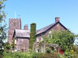 The church and Old Rectory
In the 12th century the manor was granted to William Peverell and this family name was added to the place name to give Sampford Peverell. In the medieval period, the parish church of St John the Baptist was built and was consecrated in 1259. The church retains a significant amount of the 13th century fabric in the nave and chancel. A monument within the church is believed to be of Sir Hugh Peverell, one of the church’s patrons in the 13th century. The south aisle and porch were added in 1498 by the generosity of Lady Margaret Beaufort, mother of Henry VII.
There is evidence that Sampford Peverell was a borough in a 14th century document recording 28 free burgesses in the village. In addition there was a 2 day annual fair and a weekly market.
Sampford Peverell had a castle or at least a castellated mansion built about 1337 and referred to as Sampford Castle. Its exact location is unknown but earthworks north of Sampford Barton may be the remains of this structure. There is also some evidence of either a possible moat or fish ponds.
Apart from the church dating from 13th century, the oldest building in Sampford Peverell is the Old Rectory that dates from the early 16th century, originally built as a medieval priest’s house. At this time the village belonged to Margaret Beaufort, mother of Henry VII. She had the rectory built, paid for an aisle to be added to the church, and had the leat diverted. There is more about her on our Margaret Beaufort page.
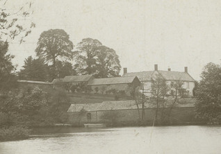 1920 view across Great Pond to Sampford Barton
The late medieval period saw the development of Lower Town, probably as a result of increasing importance of the settlement and the route through it. A map of the manor of Sampford Peverell dated 1796 (which can be found here) shows the old field boundaries including a large number of medieval strip fields, the massive pond to the western side of Higher Town (outside the conservation area) and the original settlement pattern prior to the arrival of the canal. In the 18th century Sampford Barton was constructed possibly on the site of an older building, following demolition of Sampford Castle.
In the late 16th century the village became the property of the Paulett family. Amias Paulett, who lived at the castle in Sampford, was an MP, a diplomat, and the last gaoler of Mary Queen of Scots. See our Notables page for a link to further information about him.
In the 18th century Sampford Peverell like many other rural settlements was involved in the woollen industry with much of the work carried out as a cottage industry or in small workshops. There is no obvious evidence of this cottage industry. Other industrial activity centred on quarrying and lime processing. Evidence of this can be found in the quarries and lime kilns lying to the north at Hill Quarry, Pretty Bench Quarry and on Connigar Hill.
In common with other towns and villages in the locality, Sampford Peverell has a long history of dissenters with records back to the 18th century. In 1802 a Weslyan Methodist Chapel was constructed at Higher Town. It was remodelled and extended in the latter part of the 19th century. The 200 year old building still stands on its elevated site and remains in use as a chapel. A Bible Christian (Baptist) Chapel was also established in Higher Town on the south side of the road. Whilst this building also survives its origins are obscured by conversion and alterations.
The arrival of the Grand Western Canal in the early nineteenth century had an impact on the road pattern of the village. It required the construction of a bridge to carry the turnpike road over the canal and further emphasised the separation of Higher Town and Lower Town. The Old Rectory was also partially demolished and a new rectory was built in compensation. In 1850 The Old Rectory was conveyed to the Minister and church warden for creation of a National School. The Tithe map shows the line of the canal, cutting across the old road and field pattern.
A new National School building was constructed and opened in 1874. It was extended in the 1890s. The building is still in use as a school.
The OS map 1880-90 (which can be found here) shows the Great Pond and the associated corn mill south of Sampford Barton. Sampford Mill, a three storey building, still exists although the Great Pond has disappeared, having been drained in the 1950s.